
Glossary
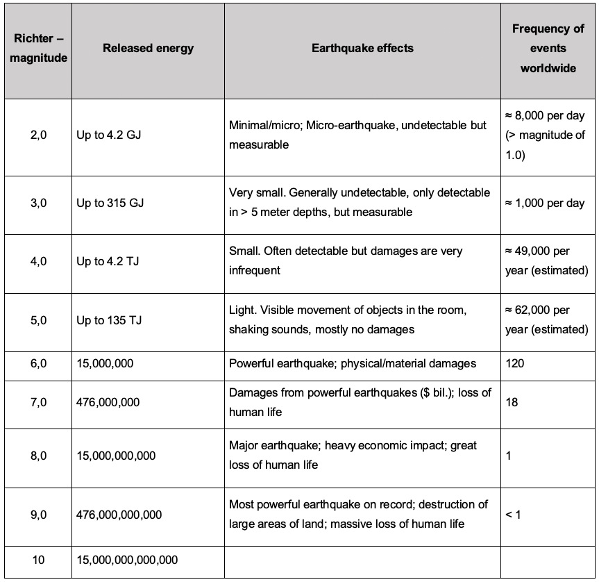
“Seismicity” in the geosciences is the technical term for the all earthquake activity in a given region – i.e. the spatial, temporal and energetic distribution of earthquakes that occur. Earthquakes are classified based on their intensity and energy. According to the definition of the USGS (U.S. Geological Survey), micro-earthquakes are when the Richter magnitude of 3 is not exceeded. Microseismicity is usually not perceptible to humans, but it is measurable and often accompanied by acoustic emissions. Worldwide, there are nearly one million earthquakes annually with a Richter magnitude of 2.
“Induced seismicity” is seismic activity caused by direct or indirect human activity, for example by disruptions from mining, oil and gas extraction, or dam and tunnel construction. Geothermal energy also disrupts the subsurface, so induced seismicity can occur on the injection side of the operation. A metro line or even large trucks can also trigger slight vibrations in the subsurface.
The stress field in the subsurface describes the natural tectonic stresses or forces and their spatial distribution on a specific volume of rock in the subsurface.
Magnitude is a metrological unit for characterizing seismic activity. It is determined from the recordings of one or more seismometers – a device that records ground motion. The scale here is logarithmic, i.e. the energy released increases 32-fold for an increase of one step on the magnitude scale. There are different magnitude types, the best known being the Richter scale for seismic activity triggered at depths of less than 20 km.
During a seismic event, a seismic wave is emitted from the starting point ¬– for example a fracture in the rock or the subsurface – that is similar to an acoustic wave after a bang. Comparable to an ambient microphone recording, seismic waves are recorded at the earth’s surface with a seismometer. The frequency, amplitude and speed of the seismic wave are determined by the type and location of the seismic activity and the geological subsurface.
Seismic monitoring is the recording and evaluation of seismic activity based on the detected wave at one or more seismometers, a so-called seismogram. The challenge for operators and scientists is above all to set up a measuring network in urban areas that geometrically records possible earthquakes effectively while picking up as little disruptive background noise as possible. To do that, new methods such as fiber optic cables and so-called mini arrays are being tested. The installation of a seismometer in a deeper borehole (approx. 170 m) can also significantly increase the quality and significance of the measurement. That makes even the smallest, imperceptible ground movements recordable. The monitoring prescribed by regulatory authorities serves to meet the requirements of applicable mining laws. Further measurements that go well beyond this can be used to understand the reservoir or the subsurface more precisely, which in turn allows the risk of an event to be better assessed.
A production borehole is a geothermal well from which deep thermal water is pumped to the surface for heat recovery while the plant is in operation.
An injection borehole is a geothermal well into which the cooled deep water is injected back into the subsurface while the plant is in operation.
Baseload serves the heat customer with the amount of energy (predominantly) needed on an ongoing basis. By contrast, peak load is only needed a small portion of the time – at higher heating temperatures on cold winter days, for example.
Together with the power and transportation revolution, the heating revolution is part of the energy transformation helping us to reduce fossil fuels and climate-relevant gases. More on geothermal energy and the heating revolution: www.waermewende-durch-geothermie.de
The subsurface is not equally stable and static everywhere. In many places, the earth rises or sinks over time – usually gradually. While in some places this happens naturally, for example through the gradual compaction of loose sediments, other ground subsidence is man-made, for example as a result of groundwater extraction, mining or large-scale building development.
Reservoir models describe how the subsurface is structured and what happens in the subsurface when humans influence it, for example through geothermal water extraction. They also explain how and whether boreholes can affect each other. Reservoir models can be divided into two categories:
- Structural geological models created by geologists and geophysicists to provide a static description of the geometry and properties of the reservoir prior to production/exploration.
- Reservoir simulation models created by reservoir engineers using numerical methods to simulate the fluid flow within the reservoir over its production lifecycle.